Downloads
Please click on the categories below to access downloads:
Links
First produced in 2006 in response to the numerous requests for coastal information that the Authority receives, the Coastal Information Pack provides in-depth data on a variety of issues that may be of interest to students or anyone else that wishes to know more about our coastline. The success of the information pack demonstrates the continued level of interest and demand for information about our coastline and paved the way for development of this interactive coastal website.
1. Development of the East Riding Coastline
The creation of the East Riding coastline began over 100,000 years ago. Since that time the coast has been changed by glaciers, ocean currents and flooding. This section explains how these processes created the coastline we see today.
2. Coastal Processes
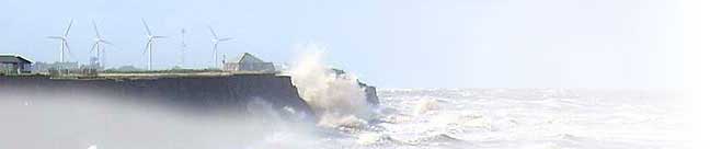
The rapid erosion of the East Riding coastline is not a new phenomenon. Since the ice age, people of this area have had to deal with its consequences. This section explains the mechanisms of erosion, and their effects.
3. Coastal Monitoring
As awareness of the sensitivity of the coast grows the value of coastal monitoring is now well recognized. Many coastal authorities and independent bodies employing a variety of techniques to survey their cliffs and beaches. This section covers the methods used to record the changing face of our coastline.
4. Defending the East Riding Coastline
Coastal engineering began with the development of ports and harbours, built to satisfy the needs of trade and the fishing industry. Over time is has evolved to include defences such as sea walls, flood banks, sand dunes and off shore structures. This section discusses the type of defences seen along the East Riding coast.
5. Spurn Peninsula
Development of the first peninsula at Spurn began following the retreat of the last ice age and the subsequent flooding of the North Sea basin about 6,000 years ago. From that time it has seen a repeated cycle of erosion and deposition. This section explains the how and why Spurn continues to change.
Monitoring of cliff erosion along the East Riding coastline began in 1951 with the establishment of over one hundred cliff erosion monitoring posts. Measurements taken from these posts to the cliff edge provided a record of erosion losses over time and could be used to estimate the areas average cliff erosion rate. Recently however with the switch over to the use of LIDAR and GPS surveying techniques and the availability of historical OS map data it has now become possible for us to estimate cliff erosion rates for any area over any time period dating way back to 1852.
This document contains the cliff erosion rates as at over one hundred designated points along the East Yorkshire Coast. The rates shown are an average rate in meters per year.
Cliff Erosion Data Table
Cliff Erosion Loss Table - Units in Meters
6. Sea State Records
Since June 2008, following the deployment of a wave buoy approximately 6km off the Hornsea frontage the Council has received real time details of the East Riding sea state. These sea state records can be accessed via the Channel Coast web site for real time data, see links page for details, or use this download section to access the monthly summary sheets.
Wave Buoy Records to April 2014