Help
Links

Basic and advanced maps- Help for usersHelp using this site
- Beach profiles Study info on coastal erosion
- PhotographsImages of our coastline and facilities
- 360 degree Photographs360 degree images of our coastline
- VideosThe coastline from the Humber to Bempton
- Frequently asked questions
- Useful DownloadsCliff erosion tables and other useful documents
- Useful linksLinks to other useful websites
- Hornsea Real-time Wave Data
- Coastal Assets DirectoryA directory of the coastal defences
- Contact detailsGet in touch with us
Measuring Cliff Erosion Rates
 The Coastal Mapper interface allows you to estimate property life expectancies using average cliff erosion rates. Click here to access Coastal Mapper
First time users of the site may find this difficult, to aid users a simple instruction manual has been produced:
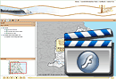
 By clicking on the following link you can view a short video of the process. Click here to access Video. [requires Adobe Flash player-see below]
Alternatively you can view the instructions at a text document. Click here to access Document [pdf: 3.5mb].
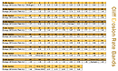
Cliff erosion rates are recorded at over one hundred designated points along the East Yorkshire Coast. The rates shown are an average rate in meters per year. Click Here to access cliff erosion rates table
Beach Profiles
As part of the East Riding of Yorkshire council's programme of coastal monitoring over 100 beach profiles are taken. These profiles have been grouped by geographical area. The following help files show how to find a beach profile and view the information attached to it.
Click Here to access beach profiles data video
Download the beach profiles data pdf
Advanced Data
The Coastal Mapper also allows you access to the Council's detailed beach monitoring data. At each of the main defended frontages and several other sites of particular interest the Council carries out a six monthly survey of their beach levels. These surveys rely upon GPS equipment to collect data on a closely spaced grid so that an accurate model of the beach surface is recorded. These Digital Terrain Models (DTM's) can be used to show simple beach level contours or when compared to previous surveys how beach levels have changed over time. This data is available for Bridlington, Barmston, Hornsea, Mappleton, Tunstall, Withernsea, Easington and Spurn.
Click Here to access advanced data video
Download the advanced data pdf
Software
Important content is available to all on this website regardless of whether you have the latest plugins or fancy software. But sometimes we do like to use other technologies to enhance the text or illustrate.
Adobe Acrobat
Adobe Acrobat Reader is needed for all files with a .pdf name extension. Acrobat Reader allows you to skip between pages of a document, view the document at different sizes and to print. You cannot edit the text in the Acrobat Reader but you can copy and paste the text into another application. Adobe Acrobat Reader is usually pre-installed on most browsers. However if it is not already installed on your PC or Mac you will need to download it before reading any PDF documents. You need to do this only once and the software is free.
Download Adobe Acrobat.
Adobe Flash Player
Download Adobe flash player to view help video